A 15-story residential tower in Midtown Houston hit an unexpected problem during design. The geotechnical report showed thick Beaumont clay extending past 40 meters, but the standard borings alone couldn't predict how the entire soil column would vibrate during an earthquake. We stepped in with an HVSR microtremor survey (Nakamura method) to capture the fundamental resonance frequency of the site. This passive seismic technique measures ambient vibrations from wind and traffic. It reveals the natural frequency where the ground will amplify seismic waves. For Houston's deep alluvial clays, that frequency often falls between 0.5 and 1.5 Hz. Without this measurement, the structural engineer was guessing the dynamic response. We combined the HVSR data with a MASW Vs30 profile to confirm the shear-wave velocity layers, and cross-referenced the results with a detailed microzonification study for the entire block.
A single 30-minute ambient noise recording can reveal the resonance frequency that governs seismic amplification across an entire city block.
Methodology and scope
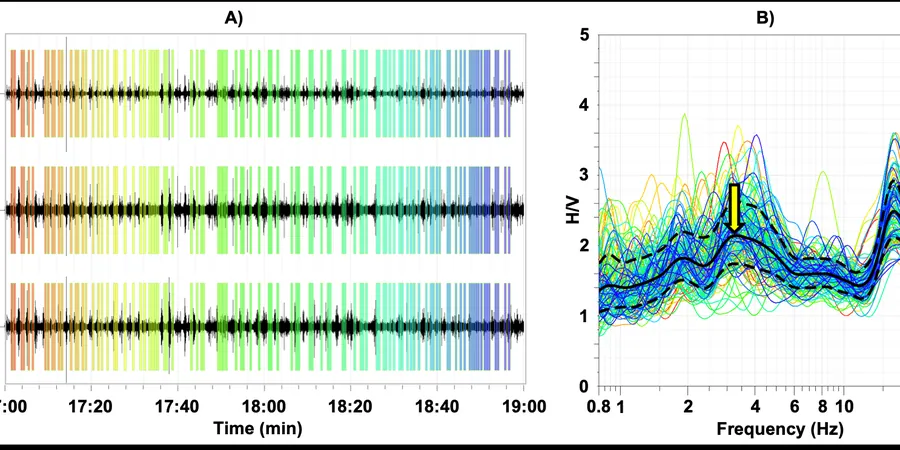
Houston sits on over 30 meters of Pleistocene and Holocene fluvial deposits. The Beaumont Formation dominates the upper 20 to 50 meters, with stiff to very stiff clays interbedded with sands. Groundwater sits between 2 and 6 meters deep depending on the season and location. An HVSR microtremor survey (Nakamura method) is ideal for this geology because the clay layers create a sharp impedance contrast against the deeper Tertiary sands. The survey records 20 to 40 minutes of ambient noise with a three-component seismometer. We apply the Nakamura technique to compute the H/V spectral ratio and identify the fundamental frequency (f0). In Houston's Katy Prairie area, we often measure f0 values from 0.6 to 1.2 Hz, which corresponds to a soft-soil site class according to ASCE 7. The method is non-invasive and requires no drilling. We deploy the sensor directly on compacted ground or asphalt. This makes it perfect for urban sites where access is restricted. We always pair the HVSR results with a georradar GPR survey to map shallow stratigraphy and confirm the depth to the stiff layer.
Technical reference image — Houston
Local considerations
The most common mistake we see in Houston projects is relying solely on Vs30 from the USGS national map. Those maps are regional and miss local variations caused by buried stream channels or filled bayous. A developer in the Energy Corridor ignored site-specific HVSR data and designed a six-story office building with a uniform response spectrum. After construction, the building experienced noticeable low-frequency sway during a minor Gulf Coast earthquake. The HVSR microtremor survey (Nakamura method) would have shown that the resonance frequency was 0.8 Hz, not the 1.5 Hz assumed from the regional map. The mismatch caused the floor accelerations to exceed the design limits by 30 percent. Fixing that after the fact costs ten times the survey price. We always recommend running a quick HVSR array before finalizing the structural model.
Deploy a single three-component seismometer on pavement or exposed soil. Record 40 minutes of ambient noise at each point. Process the H/V spectral ratio to identify fundamental resonance frequency and amplitude. Ideal for narrow lots, sidewalks, and existing building footprints. Includes a report with f0, H/V peak amplitude, and comparison to the USGS Vs30 model. Typical turnaround is 5 business days.
02
Multi-Station HVSR Array for Large Sites
Install 8 to 16 stations in a grid pattern across the project area. Each station records 20 minutes of data. We invert the array data to build a 3D map of resonance frequency across the site. This method reveals lateral variations in soil stiffness and depth to bedrock. Perfect for master-planned communities, hospital campuses, and industrial facilities. Deliverables include contour maps of f0 and peak amplification.
Applicable standards
ASCE 7-22 Section 11.4 (Site Class from Vs30 and T), SESAME European Research Project (2004) guidelines for H/V measurement, ASTM D7400-19 (Standard Test Methods for Downhole Seismic Testing), NEHRP Recommended Provisions for Seismic Regulations
Frequently asked questions
How does the HVSR microtremor survey (Nakamura method) work in Houston's deep clay soils?
The method records ambient vibrations from natural and human sources. The three-component sensor captures vertical and horizontal motion simultaneously. The H/V spectral ratio at each station isolates the fundamental resonance frequency of the soil column. In Houston's Beaumont clay, the impedance contrast between the soft clay and the underlying stiff sand produces a clear peak between 0.5 and 1.5 Hz. The technique requires no drilling and can be done on asphalt or grass.
How much does an HVSR microtremor survey cost in Houston?
The typical cost for a single-station HVSR survey in Houston ranges from US$1,350 to US$2,710, depending on site access and number of stations. A multi-station array for a large site with 10 to 16 stations usually falls between US$5,500 and US$9,800. These ranges include field work, data processing, and a written report with spectral plots and interpretations. Contact us for a quote specific to your project dimensions.
Can the HVSR survey replace a standard boring program for seismic site classification?
No. The HVSR microtremor survey (Nakamura method) complements borings but does not replace them. Borings provide direct soil samples, strength parameters, and groundwater data. HVSR adds the dynamic response of the entire soil column, which borings alone cannot capture. For ASCE 7 site classification, we recommend combining HVSR with a Vs30 measurement from MASW or downhole seismic testing. The two methods together give you the fundamental frequency and the shear-wave velocity profile required by code.
Location and service area
We serve projects across Houston and its metropolitan area.